11 HARKNESS RD
Owner Information
BUSH BERNARD T
11 HARKNESS RD., P O BOX 412
MILLVILLE, MA 01529-0412


Property Details
11 HARKNESS RD is classified as a Single Family Residential (Cape).
The primary structure on this property was built in 1974. There are 1,344ft2 of built area within this property. There is 1,344ft2 of residential/living space within this property. This property is listed as having 6 rooms.
11 HARKNESS RD is valued at $300,400. The land is valued at $97,000 and the structures are valued at $180,700. There is an additional valuation of $22,700 on this property.
This property is in Zone VRD. Confirm with local Zoning Board authorities to ensure there are no overlays or other easements on this property.
The most recent deed for 11 HARKNESS RD is recorded at the local registrar in Book 46817, Page 256. 11 HARKNESS RD was last sold on Wednesday, December 8, 2010 for $100.
Assessment data from fiscal year 2021.
Flood Data
According to the FEMA National Flood Hazard Layer, this property does not appear to be in a flood zone. It may also be in an area not yet reviewed. Nonetheless, confirm this information prior to taking any action.
To view the flood hazards around this property, create a FEMA "Firmette" Map of the area around 11 HARKNESS RD.
Broadband Internet Providers
| Provider | Type | Bandwidth (mbps) | |
|---|---|---|---|
| VSAT Systems, LLC. | Satellite | 2 | 1 |
| Charter Communications Inc | Cable | 940 | 35 |
| Viasat Inc | Satellite | 100 | 3 |
| Verizon New England Inc. | DSL | 5 | 0 |
| GCI Communication Corp. | Satellite | 0 | 0 |
| T-Mobile | Fixed Wireless | 25 | 3 |
| HughesNet | Satellite | 25 | 3 |
Broadband service provider data from December 2020.
Adjacent Properties
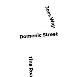
- 20 DOMENIC ST
Single Family Residential owned by PACHECO BRIAN P & TARA LEE R - 7 TINA RD
Single Family Residential owned by HARVEY JEFFREY A & RANDI D - 3 TINA RD
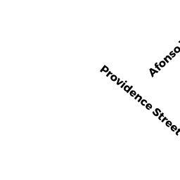
Single Family Residential owned by ALLEN JUSTIN R - 14 PROVIDENCE ST
Single Family Residential owned by SMART MARTIN - 5 HARKNESS RD
Single Family Residential owned by MANDEVILLE MARC A, TRUSTEE